Ziguinchor Department (Ziguinchor)
 |
The department has a single urban commune, that of Ziguinchor
The department is also divided administratively into two arrondissements, Niaguis Arrondissement and Nyassia Arrondissement which are in turn split into rural communities (Communautés rurales).
* Niaguis Arrondissement:
* Adéane
* Niaguis
* Boutoupa-Camaracounda
* Nyassia Arrondissement:
* Enampore
* Nyassia
Map - Ziguinchor Department (Ziguinchor)
Map


Country - Senegal
 |
 |
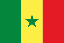
| Flag of Senegal | |
Senegal is notably the westernmost country in the mainland of the Old World, or Afro-Eurasia. It owes its name to the Senegal River, which borders it to the east and north. The climate is typically Sahelian, though there is a rainy season. Senegal covers a land area of almost 197000 km2 and has a population of around million. The state is a unitary presidential republic; since the country's foundation in 1960, it has been recognized as one of the most stable countries on the African continent.
Currency / Language
| ISO | Currency | Symbol | Significant figures |
|---|---|---|---|
| XOF | West African CFA franc | Fr | 0 |
| ISO | Language |
|---|---|
| FR | French language |
| WO | Wolof language |